Home »
Misc »
How many laps around the basketball court is a mile
How many laps around the basketball court is a mile
How Many Laps Around a Basketball Court is a Mile?
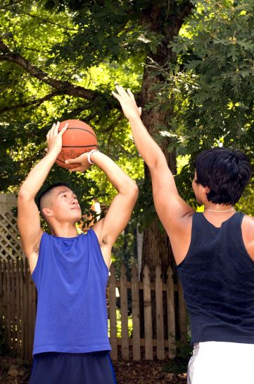
Have you have ever played on an organized basketball team as a kid or young adult? If so, then you have probably had the experience of running laps around the basketball court. Whether it is for warm-ups or as punishment, it can be a common part of basketball practice for young players.
Let’s face it, basketball involves a lot of running, especially when playing full-court ball. So the real intent of coaches making us run laps around the court was to get us in shape and help us to have good stamina. Coupling all of that running with defense and shooting drills and it will build in-game stamina even more.
So, with all that running around the court, did you ever wonder how many laps you had to run around it to go a mile? I used to think about it while I was running, but I never really stopped to figure it out. In fact, it is quite easy to calculate but let’s first take a look at the quick answer. After that, we can discuss how it is calculated and whether or not there are differences for different court sizes such as youth, high school, college, and NBA.![]()
Quick Navigation
Quick Answer
If you were running laps in high school, you were most likely on a regulation size high school court. For this size court, it would have taken you about 19.7 laps to run a mile. This means that those 20 laps your coach made you run for being late to practice was a little over a mile.
My Personal Experience
Sure, I have run plenty of laps around the basketball court as a player but I have a somewhat funny story from the perspective of a coach. As a coach of my daughter’s rec league team, I never had players run laps for being late, but I did have them run laps to warm up. One particular season, there was a young lady that was consistently late to practice.
Oddly enough, this young lady would always show up just as we were completing our warm-up laps around the court. This player also happened to be a friend of my daughter. Since I was a little concerned about her, I asked my daughter to see if she could find out why she was always late. Maybe she needed a ride to practice.
Sure enough, my daughter found out that the player was purposely coming late so that she could avoid running laps. In fact, she would have her mother take her out to eat and stay long enough so that she could be late to practice and miss warm-up laps. There was no doubt in my mind that the mother was in on it also and allowing her daughter to miss warm-up laps.
Once I found out what was going on, I changed up my practices so that at the beginning we played fun games like HORSE, knock out or 21. Once this young lady arrived at practice, we would immediately stop the game and I would announce that she was there and that we can now start running warm-up laps.
Needless to say, she started getting to practice on time and we went back to running warmup laps as normal. We would run 5 laps, probably about ¼ of a mile (and yes, I would run with them).
How to Calculate the Number of Laps in a Mile
So, let’s get back to discussing how many laps around a basketball court equal a mile.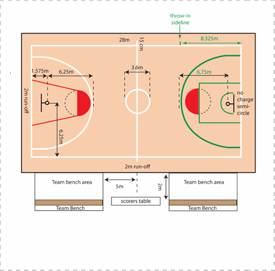 Above we saw that it takes 19.7 laps to complete a mile around a high school size basketball court. So you might be wondering, how did we come up with that number? It is rather simple to calculate. Let’s dissect it a little deeper.
We can find out using basic math. If you remember back to your 6th-grade geometry class, the key to this is calculating the perimeter of the basketball court. If you don’t remember what perimeter is, don’t worry, it’s been a long time since the 6th-grade for many of us, so we will bring you up to speed (there won’t be a quiz at the end either).
The perimeter is the length or distance around the outside of a shape. In this case, it is the rectangle shape of the basketball court. If you know the length and width of the basketball court, you can calculate the perimeter using the following equation :
Perimeter = 2 x Length + 2 x Width
Or for short
P = 2L +2W
See the photo below and this might make a little more sense.
The perimeter of a rectangle or basketball court. Photo by Melissa Medina
Our measurement for perimeter will be in feet, so we will need to convert 1 mile into feet also.
1 Mile = 5280 feet.
Now to find the number of laps around a court we just need to divide the number of feet in a mile by the perimeter so we will have the following equation.
Laps per mile = 5280/P or 5280/(2L+2W)
For our standard highschool court which has a length of 84 feet and a width of 50 feet we can now plug the number in as such :
Laps per mile = 5280/(2×84 + 2×50)
= 5280/(168+100)
= 5280/268
= 19.7 laps
Easy right? It probably just took a quick refresher to remember how to calculate perimeter and complete some simple division. One thing that we must remember is that basketball courts for different levels such as high school, college, NBA, FIBA, and others are all different.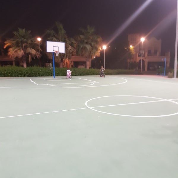 Now that we have an easy way to calculate laps per mile, let’s take a look at what is for other courts.
Laps per Mile for other courts
Below are the dimensions of other regulation courts. We can use these length and width measurements to calculate the number of laps around these courts also. Note that US college and NBA courts have the same measurement.
College/NBA
Length = 94 ft.
Width = 50 ft.
Laps per mile = 5280/(2×94 + 2×50) = 18.33
High school
Length = 84 ft.
Width = 50 ft.
Laps per mile = 5280/(2×84 + 2×50) = 19.7
Junior High school
Length = 74 ft.
Width = 42 ft.
Laps per mile = 5280/(2×74 + 2×42) = 23.2
FIBA/Olympic (measured in meters so we need to convert to feet)
Length = 28m = 91.9 ft.
Width = 15m = 49.2 ft.
Laps per mile = 5280/(2×91.9 + 2×49.2) = 18.6
There may be other size courts, such as ones in elementary schools and exercise gyms. It’s hard to say what the length and width of these courts are because they are most likely not standard in size. All you need to do is find the length and width and you can now calculate the number of laps needed for a mile.
Final Words
As you can see, once you know the length and width of the court or any other area that you are planning on running around, you can calculate the number of laps it takes to run a mile. You can even calculate the number of laps needed to run a mile on your own basketball court in your driveway or back yard.
What kind of basketball coach did you have? Did you have to run laps for making mistakes or being late? We’d love to hear your interesting stories.
How Many Laps Around Different Basketball Courts Make a Mile
Are you new to the hoops game? Or a coach looking to improve the conditioning of your players? If so, you may be wondering how many laps around the basketball court make a mile.
When it comes time to run laps, keep in mind that all basketball courts don’t have the same dimensions. Find out how many laps around different sized courts you need to run to make a mile in this post. We’ll be using the dimensions of an indoor basketball court at each level.
Table of Contents
- Dimensions of Different Basketball Courts
- How Many Laps Around Each Court Makes a Mile
- How Many Laps Around Each Court Makes a Half-Mile
- How Many Laps Around Each Court Makes a Quarter Mile
- What Are the Dimensions of Olympic Basketball Courts?
- Why Do Basketball Coaches Make Players Run Laps?
Dimensions of Different Basketball CourtsDid you know that not all basketball courts are the same size? The perimeter of each court varies depending on the age and skill level of the basketball players. Here is a closer look at the dimensions for each different court.
Junior high basketball courts are 74 feet long and 42 feet wide. A kid playing youth basketball is normally in the sixth, seventh, or eighth grade, so the smaller sized court makes more sense for them. You wouldn’t want to put young players on a standard high school court.
A high school court is 84 feet in length. The width of the basketball court in high school is 50 feet. Since high school basketball players are older and larger than junior high players, playing on a junior high court would be too easy for them.
Basketball courts in the NBA and college basketball are 94 feet long and 50 feet wide. Note that there is no change in width from the high school level to the college and professional level. The only change is in the length of the court.
How Many Laps Around Each Court Makes a MileThis question comes down to simple math. We know that the number of feet per mile is 5,280. Now, we simply have to take the length of the court and multiply it by 2. We will do the same calculation for the width of the court.
Junior High SchoolAfter finding this number, we are ready to do our calculations. So, for a junior high basketball court, we take the length of 74 feet and multiply it by 2 for a total of 148 feet.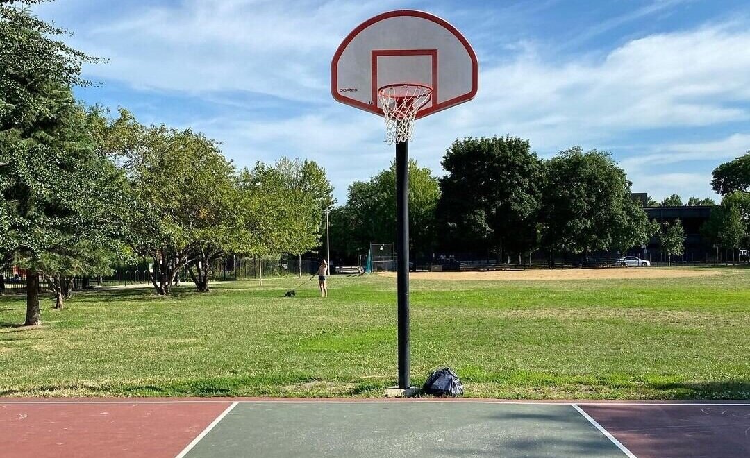 We also take the length of 42 feet and multiply it by two for a total of 84 feet.
Now, we’ll add those two numbers together for a total of 232 feet. Next, we take the one-mile total of 5,280 feet and divide it by 232 feet. This means that it will take 22.75 laps on a junior high school basketball court to make a mile.
High SchoolFor a high school basketball court, we take the 84 feet in length and multiply it by 2 for a total of 168. We take the width of 50 feet and multiply it by 2 to get 100. That leaves us with a total of 268 feet for one lap.
Again, we divide 5,280 feet by 268 feet. That tells us that it takes 19.7 laps to make a mile on a high school basketball court.
College and NBANow we get to the big boys. Both college basketball courts and NBA courts have the same dimensions of 94 feet long by 50 feet wide. Let’s follow the same mathematical procedure.
We take 94 and multiply by 2 to get 188 feet. We take 50 feet and multiply it by 2 to get to 100 feet. This gives us a total of 288 feet.
After dividing 5,280 feet by 288 feet, we see that it takes 18.33 laps to make a mile on both college and National Basketball Association courts.
How Many Laps Around Each Court Makes a Half-MileNow that we have the formula down, finding out how many laps it takes to make a half-mile is pretty simple. Just take our other answers and divide them by 2.
- So, using that formula we see that it takes 11.375 laps on a junior high school basketball court to make a half-mile.
- A high school basketball player will have to run 9.85 laps to make a half-mile.
- It takes 9.165 laps on an NCAA basketball court to make it a half-mile. It’s the same on an NBA court
How Many Laps Around Each Court Makes a Quarter MileAgain, since we know the formula, we can find these answers fairly quickly. All we have to do is take our original answers for one mile and divide them by 4.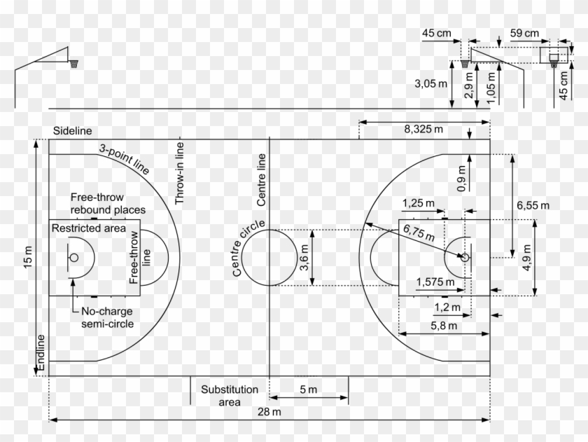
We already know that it takes 22.75 laps to make a full mile on a junior high basketball court. So, that means that it will take a player 5.69 laps to make it a quarter-mile on a junior high basketball court. (22.75 / 4 = 5.6875)
Using that same formula, we also see that a player will only need to run 4.93 laps to make a quarter-mile on a high school basketball court. How’d we get to that number? Take the 19.7 laps that it takes to make a full mile on a high school court and divide by 4. (19.7 / 4 = 4.925)
To figure out what makes a quarter-mile on an NCAA basketball court or an NBA court, take the 18.33 laps that it takes to make one mile and divide by 4. That standard set of measurements tells us that it takes 4.58 laps to run a quarter-mile on a college or NBA basketball court. (18.33 / 4 = 4.5825)
What Are the Dimensions of Olympic Basketball Courts?Many folks assume that Olympic basketball courts have the same dimensions as NBA courts. Surprisingly, that is not the case.
An International Basketball Federation (FIBA) court is a tiny bit smaller than an NBA court. An NBA court is 50 feet wide, while an Olympic court is only 49 feet wide. A FIBA court is also two feet shorter in length than an NBA court (92 ft vs 94 ft).
Another stark difference between the two courts is the dimensions of the three-point line. The three-point line in the NBA is 22 feet away from the basket in the corners. The FIBA three-point line is only 21.65 feet away from the basket in the corners.
Directly above the break, the NBA three-point line is 23.75 feet away while the FIBA three-point line is 22.15 feet away. Those minute differences may not sound like a lot, but professional basketball players are remarkably more accurate the closer they are to the basket.
Why Do Basketball Coaches Make Players Run Laps?At all levels of basketball, coaches have players run laps around the gym. They do this for a couple of reasons, which we will discuss below.
Punishment
This reason is probably the most common. Coaches are notorious for making their players run laps as punishment for poor performance on defense during a game. They also may make players run laps when they do certain basketball drills incorrectly during practice.
For example, my junior high basketball coach used to make each player run one lap for every free throw that he missed during the game. Other coaches may make their players run one full-court sprint for each time that they turned the ball over during the game.
Conditioning
Basketball is a tough game and it requires that each player be in good cardiovascular condition to play full-court ball. For that reason, coaches will order players to run laps before or after practice. If you hate running, you should have reservations about playing organized basketball.
Running laps helps build up a player’s stamina so that he won’t get tired in the latter stages of a game. No basketball coach wants to see any of his players gasping for air during crunch time.
A popular form of conditioning is called running “suicides”. To run a suicide, a player starts at the end line underneath the backboard. He then runs from the end line to the free-throw line and back to the end line.
Next, the player sprints from the end line to the half-court line and back. He then runs from the end line to the other free throw line and back. Finally, he runs from one end line to the other end line and back. The crazy thing is that all of that sprinting only counts as one suicide.
Mike Noblin
Mike has been involved with basketball for over 30 years as a player, coach, and bettor. He has a degree in Sports Psychology and enjoys following both the NBA and College Basketball on a nightly basis.
Basketball court markings: standards and norms
Author of the article
Dmitry Khvatkov
Consultant in the production of rubber coatings
Basketball field marking requirements are approved by the FIBA standard.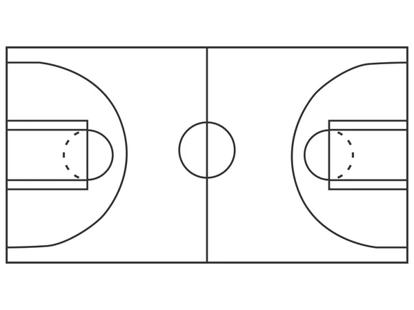 The site must be flat with a hard surface, without bends, cracks and other obstacles. The accepted dimensions of the field are 28 m long and 16 m wide. By NBA standards, the field is slightly larger: 28.7 m (94' ft) long and 15.3 m (50' ft) wide.
Areas not intended for international competitions may differ from accepted standards (for public use, in schools or universities, etc.) and usually vary from 20 to 28 m in length and from 12 to 16 m in width.
Basketball Court Marking Standards
Basketball court markings are conventionally divided into 5 components:
- Boundary lines. They are located along the perimeter of the site and set its size. The lines that run along the field are called side lines, and those that are behind the baskets are called front lines.
- Central line. Divides the court in half parallel to the front lines.
- Central zone. It is a circle and is placed in the middle of the center line, and, accordingly, in the center of the entire field.
- Three-point line. It is a semi-ellipse and is located around the shields on both sides of the field. It limits the close range.
- Free throw line. It is located in front of the boards parallel to the front line and is limited on the sides by paint lines.
The standard line width is 5 cm. All outlines and lines must be of the same color (usually white) and be clearly visible from anywhere on the court.
Common lines
Common lines are used to limit the playing area of the court. The side lines (along the field) according to FIBA standards should be 28 m long, and the front lines - 16 m. For public areas, deviations from the accepted standards are allowed. Typically, basketball courts in schools or gyms are made from 20 m long and 12 m wide.
Central lines
The center line is parallel to the front and divides the field exactly in half. According to the standards - it should extend beyond the side lines by 15 cm on both sides.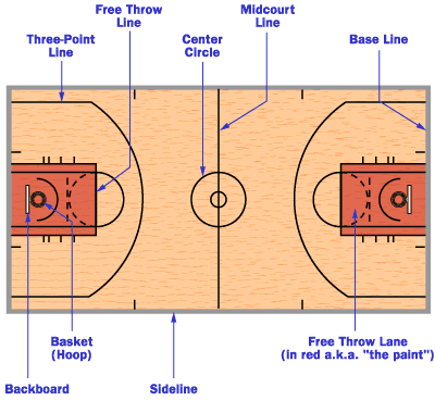
In the middle of the center line there is a circle with a diameter of 3.6 m, which limits the central zone of the field. In this zone, the ball is played at the beginning of the game.
Three-Point Line
Three-Point Lines are located around the backboards on both sides of the field and consist of two straight lines 2.9 long9 m and a semicircle. Straight lines run perpendicular to the front at a distance of 0.9 m from the side lines. Despite the fact that visually the distance from the ring to the side of the three-point line seems to be less than to its central part, the distance from the backboard to any point is 6.75 m.
Penalty lines
Penalty lines limit the nearest area at the backboard. They consist of a trapezoid and a free throw zone.
Despite the name, the "trapezium" is a rectangle (until 2009year it really was a trapezoid), which is located under the shield. Its dimensions are 5.8 meters long and 4.9 meters wide. The shield is located at a distance of 1. 575 m from the end line in the middle of the site. In front of the backboard, at a distance of 1.25 m, there is a semicircle that limits the area for picking up the ball.
At a distance of 4.225 meters from the backboard, the trapeze zone ends and the free throw zone begins. It is a semicircle with a diameter of 3.6 m (like the central circle).
Paint zone lines
These lines are serifs on both sides of the trapezoid (parallel to the sidelines). They limit the areas for players who are fighting for the ball during a free throw.
Zones on the basketball field
The basketball court is divided into zones using markings. Each zone has its own specific rules.
Center circle
The center circle is used as a separate kick-off area at the start of the game. One representative from each team stand in a circle from their side and fight for the ball in a jump, after it is dropped by the referee. All players are exclusively on their side of the field, except for one who rebounds on the opponent's side.
Neutral zone
The peculiarity of this zone is that as soon as the player of the attacking team with the ball crosses the center line and is on the side of the opponent, he cannot pass the ball to the player of his team who is on the other side of the field (i.e. behind center line on your side).
Three-point zone
The three-point line limits the near zone of the shot. Hitting the basket from outside the basket brings the team three points. If the throw was made inside the zone, then it brings two points.
Three-second zone
This is the zone in close proximity to the ring. It is called three-second, since the player of the attacking team cannot be in it for more than three seconds. Most balls are thrown in this zone, so when attacking, it provides maximum protection.
Free throw area
In controversial situations, a free throw is provided from this area. The player of the attacking team must score the ball without stepping over the line of the trapezoid. At the same time, the players of both teams are not in the three-second zone. They take up positions along the paint lines on the sides of the trapezoid and may not step outside the lines until the free throw shooter has shot the ball.
How to mark a basketball field?
Basketball field markings, whether it is an international competition court or an open-air amateur field, are best applied using special equipment. This will ensure the long life of the coating, the lines will not clog and will promote fair play.
You can order the marking of a basketball court in Moscow and the Moscow region from Rezkom. We will measure the premises and develop a design project for the field so that it complies with generally accepted rules and is convenient for operation. For more details, you can contact our manager by phone 8-495-64-24-111.
Parks - Sedalia Parks
To enroll in our programs, visit the parks and recreation office or call (660) 826.4930 .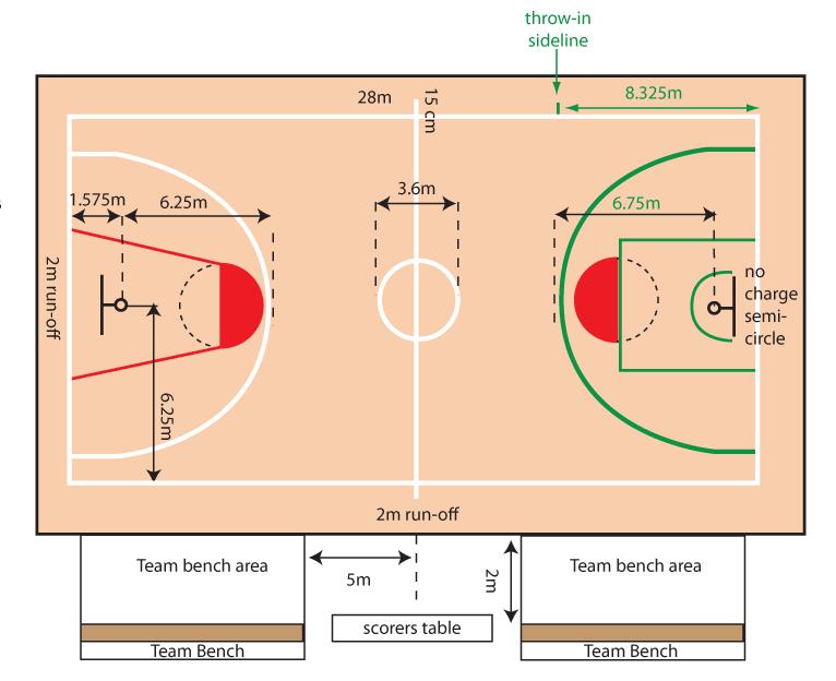
Payment is required at the time of registration. We accept cash, checks, Visa, MasterCard, Discover and American Express.
You can also register online (for most events) at https://registration.sedaliaparks.com.
Late Registration Policy: If space permits and we accept registrations after the deadline, a $5 late fee will apply to programs and a $20 late fee will apply to all leagues.
Conference room rental
Event gym rental is $300 per day. Damage deposit for gym rentals is $300 per day. Some rentals may require insurance. Call the park office at 660-826-4930.
Centennial Park
The fifth park to be added to the park system was Centennial Park in 1960. Centennial Park, located on the corner of 16th Street and New York, is the second largest of all existing parks, its area is 39acres. The main function of this park is an outdoor sports complex consisting of 8 illuminated ball fields and a swimming pool.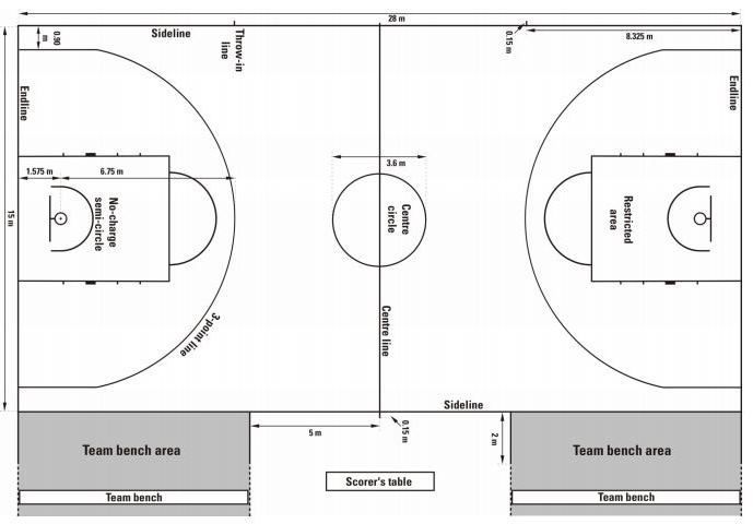 There are security lighting, playgrounds, swings, slides, climbing walls and five shelters.
Map of Centennial Park here.
Centennial Park 3D Tour here.
Directions
From North or South :
From North: 65 Hwy (Limit Avenue) to 16th Street, turn left. Continue on 16th Street for approximately 2.3 miles.
From the south: 65 Hwy (Limit Avenue) to 16th Street, turn right. Continue on 16th Street for approximately 2.3 miles.
Centennial Pool will be on your right. To access other parts of the park, continue on 16th Street and turn right onto New York Ave. The playground, awnings and ball courts will be on your right.
East or West :
East: 50 Hwy (Broadway) to New York Avenue, turn left.
From West: 50 Hwy (Broadway) to New York Avenue, turn right.
At New York Avenue and 16th Street, turn right at Centennial Pool or continue straight ahead to access other parts of the park. The playground, awnings and ball courts will be on your right.
Clover Dell Park
The seventh and most recent park to be added to the system is Clover Dell Regional Park. Clover Dell is located on West 32nd Street, 8/10 miles from the city limits. Clover Dell is a 173 acre park. Completed a football complex with concession facilities and recreational facilities, and a 12-acre lake in collaboration with the Department of Conservation's Community Assistance Program. 8 soccer fields, 18-hole frisbee golf course, access to Katy Tail, Clover Dell Lake, shelter, restrooms. The RC Track shown on the map is currently unusable.
Clover Dell park map here.
Clover Dell Park 3D Tour here
Directions:
From North: 65 Hwy to 32nd Street traffic light, turn right. There will be a fork in the road; you need to immediately turn right to stay on 32nd street. Continue on 32nd Street for approximately 1.5 miles, the park entrance is on the left.
From South: 65 Hwy to 32nd Street traffic light, turn left. There will be a fork in the road; you will need to turn right immediately to stay on 32nd Street. Continue on 32nd Street for approximately 1.5 miles, the park entrance is on the left.
East: 50 Hwy to 65 Hwy, turn left. 65 Hwy to 32nd Street traffic light, turn right. There will be a fork in the road; you need to immediately turn right to stay on 32nd street. Continue on 32nd Street for approximately 1.5 miles, the park entrance is on the left.
From West: 50 Hwy to 65 Hwy, turn right. 65 Hwy to 32nd Street traffic light, turn right. There will be a fork in the road; you need to immediately turn right to stay on 32nd street. Continue on 32nd Street for approximately 1.5 miles, the park entrance is on the left.
Dog Park
Located in Clover Dell Park and free to the public. No membership or fee required! There is a fenced area for large and small dogs.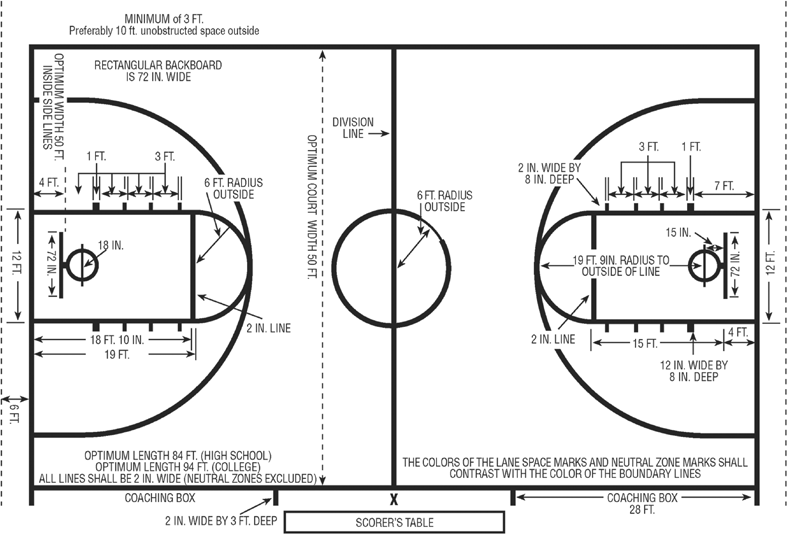 Bring your friendly four-legged friends for some fun!
Dog Park Rules and Regulations
Housel Park
The third park included in the park system was Housel Park, which was acquired in 1942 and expanded in 1973 and 1984. Housel Park is located at Howard and Hurley and has an area of about five acres. Housel Park has one very active ball court, as well as restrooms, two cabins, a toddler playground, an illuminated basketball court, security lighting, swings, a slide, and ancillary facilities.
Map of Howsel Park here.
Housel Park 3D tour here
Hubbard Park
The second park in the Sedalia park system is Hubbard Park, which was a gift from Mrs. Cotton at 1921 years old. Hubbard is located on Johnson and Missouri Streets and has 23 acres. Hubbard consists of five cabins, lighting, fountains, two restrooms, a lighted baseball field, as well as swings, slides, a new modular play system, and two basketball courts. It also has a concession kiosk and ancillary facilities.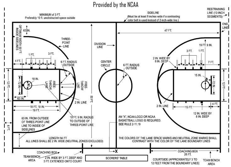
Map of Hubbard Park here.
Hubbard Park 3D tour here
Directions
From North: 65 Hwy to 3rd street, turn left. Third street to Missouri, turn left. The park will be on your left.
From South: 65 Hwy to Main Street exit. After the exit, turn right onto Main St. Turn left onto Missouri Avenue, the park will be on your left.
From East: 50 Hwy to Grand Ave, turn right. Turn right onto Cooper Street. Turn left onto Missouri; the entrance to the park will be on your left.
From West: 50 Hwy to 65 Hwy, turn left. Main Street exit, turn right onto Main St. Turn left onto Missouri Avenue, the park will be on your left.
Swimming area
Opening May 26, 2022!
Final weekend - Friday, September 30 - Sunday, October 2.
Closing on Monday 3 October until next summer.
Opening Hours: 10 am - 8 pm
Free and open to the public
Terms of use of the site can be found here.
Unfortunately, there are no private rentals at the moment.
Cathy Park
The sixth park to be added to the system is Cathy Park. Katy Park is located on the corner of 24th and Grand and has an area of 18 acres. Recently, Katy Park has undergone some changes with a skate park, a modular playground, toilets, fountains and electricity in the cabins. Katy Park was purchased in 1974 and completed in 1976 with grant funds. It also has a baseball practice field, two recreational houses and one bouncer football driving range.
Map of Cathy Park here.
Katy Park 3D Tour here
Directions:
From North: 65 Hwy (Limit Avenue) to 16th Street, turn left. 16th Street to Grand Avenue, turn right. For the skate park, turn right onto Clinton Rd; the skate park will be on your left. For the playground and sheds, continue down Grand Avenue and turn right onto 24th Street; these zones will be on your right.
South: 65 Hwy (Limit Avenue) to 32nd Street, turn right. Turn left immediately onto Clinton Rd. For the playground and sheds, turn right onto 24th Street; the park areas will be on your left. For the skate park, continue on Clinton Road; the skate park will be on your right.
East: 50 Hwy to Grand Avenue, turn left. For the skate park, turn right onto Clinton Rd; the skate park will be on your left. For the playground and sheds, continue down Grand Avenue and turn right onto 24th Street; these zones will be on your right.
From West: 50 Hwy to Grand Avenue, turn right. For the skate park, turn right onto Clinton Rd; the skate park will be on your left. For the playground and sheds, continue down Grand Avenue and turn right onto 24th Street; these zones will be on your right.
Skate Park
KATY PARK (Clinton Road and Grand Avenue)
Completed September 2003
9002 SKATE PARK RULES & REGULATIONS WARNING! The object is unattended and not insured.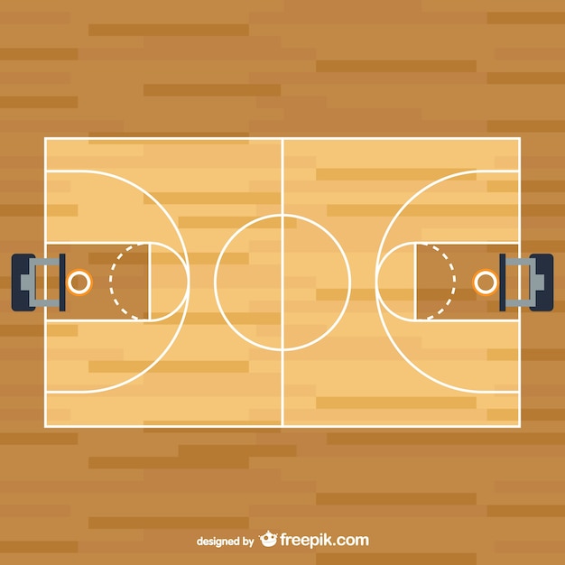
Any use is at your own risk. Use may result in serious injury.
PROTECTIVE EQUIPMENT
We strongly recommend that you wear the following protective equipment at all times to ensure adequate protection in the event of a fall or collision:
Helmet * Knee pads * Elbow pads * Wrist pads
PLEASE REMEMBER
* The Skate Park is for skateboards, skateboards and inline skaters. Bicycles and scooters are prohibited.
Hours of permitted use are from 7:00 am to sunset. It is illegal for any person to enter the territory outside the established hours.
* The Sedalia Parks and Recreation Department is not responsible for any activities at this location.
* Do not use glass containers, food or drinks on the skating surface. Spilled products endanger riders.
* Other items such as benches, tables, wooden materials or other items used as ramps or springboards are not allowed in the skate park.
* Pets are not allowed on the skate park.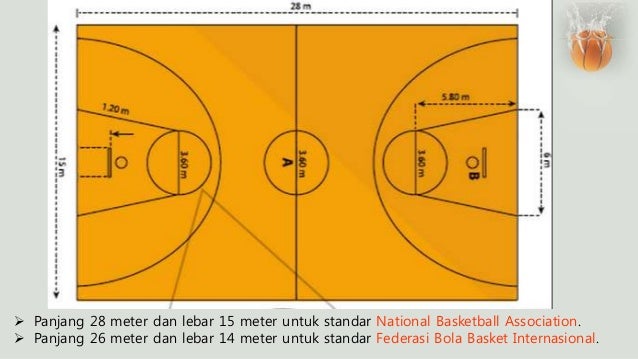
* It is forbidden to ride against the traffic.
* Do not leave the ramp until you have freed it from other skaters.
* Alcohol, tobacco and/or drugs are prohibited.
SEDALIA PARKS AND RECREATION DEPARTMENT
RESERVES THE RIGHT:
* Close the facility under any circumstances deemed necessary.
* Restrict entry to the property and deny access to the property if any of the
rules or if unsafe behavior is observed (Park Board Policy).
PLEASE REMEMBER
Ride safe and be aware that weather conditions can create unsafe surfaces to ride.
FACILITY MAINTENANCE
Please report maintenance issues to the park and recreation office 826-4930. Messages can be left 24 hours a day.
SERIOUS INJURIES
In the event of a serious injury or other emergency, call 911. The phone is located in the northeast corner of the parking lot, next to the walking trail. The facility is located in Katy Park, on the corner of South Grand and Clinton Road.
PLEASE BE POLITE AND RIDE FRIENDLY
Liberty Park
Liberty Park is approximately 32 acres and was acquired in 1890 by Joseph Seacher. Today, Liberty Park is home to the main building, Convention Hall, which houses the parks and recreation office. The building has an auditorium for recreation programs, an upper floor for dance programs and conference rooms, as well as toilets.
The Parks Management and Operations Office is also located in Liberty Park. This office houses the maintenance staff and all the equipment to keep the facilities in proper condition.
We have security lighting, fountains, playground equipment, two basketball courts, six floodlit tennis courts, six recreation houses, a recreational fishing lake, a rose garden, a floodlit baseball stadium with seating, restrooms and a concession kiosk, picnic areas, sand volleyball courts, the Liberty Land train with 1/8 mile track, and a lighted Little League baseball stadium.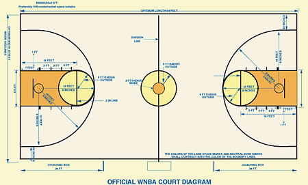
Map of Liberty Park here.
Freedom Park 3D Tour here
Directions
From North: 65 Hwy (Limit Ave) to 3rd Street, turn left.
South: 65 Hwy (Limit Ave) to 3rd Street, turn right.
East: 50 Hwy to 65 Hwy, turn right. Turn right onto 3rd Street.
From West: 50 Hwy - 65 Hwy, turn left. Turn right onto 3rd Street.
Once you are on 3rd Street, Liberty Pool and other areas of Liberty Park will be on your left.
Moore Railway House
More details on the opening date for the 2022 season will follow shortly.
Moore Railroad Home - Home of the Liberty Land Train
Hours of Operation
Saturdays 11:30am - 3:30pm
Sundays 1:00pm - 4:00pm
$2 per wristband for the whole day; cash only per day
All ages must purchase a bracelet
Snacks and goods from the railway house are available in the shop!0003
Vermont Park
Vermont Park - upgraded in 2017
The fourth park to be added to the system was Vermont Park in 1951.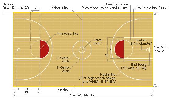 Pfeiffer Woods-Vermont Park is located on the corner of Vermont and 14th Street and is approximately 7 acres in size. Vermont Park was renamed Pfeiffer Woods - Vermont Park in 1986. Pfeiffer Woods-Vermont Park includes: basketball court, multi-purpose court, play areas, 2 small driving ranges, lighting and toilet shed, and a NEW walking path (.294 miles. 3.5 laps = 1 mile).
Map of Vermont Park here.
Vermont Park 3D tour here.
Reservations cannot be made more than one year before the start of the rental.
Deadline for weekend rentals is Thursday before rental. The rental period on weekdays is two working days before the rental.
DIMENSIONS, NUMBER OF TABLES, SEATS AND PRICES - FROM JANUARY 1:
- Large size - 16 tables, seating approximately 100 people - $35
- Medium size - 10 tables, seating approximately 60 - $30
- Small size - 6 tables, seating approximately 35 - $25
- Hubbard Concession - $80
- Deposit for the hubbard key - $50
- The cost of renting the shelter will increase by $5 annually until 2025.
Shelter Rental and Special Event Permit Policy
Event Gym rental costs $300 per day. Damage deposit for gym rentals is $300 per day. Some rentals may require insurance. Call the park office at 660-826-4930.
The fifth park to be added to the park system was Centennial Park in 1960. Centennial Park, located on the corner of 16th Street and New York City, is the second largest park in existence, covering 39 acres. The main function of this park is an outdoor sports complex consisting of 8 illuminated ball fields and a swimming pool. There are security lighting, playgrounds, swings, slides, climbing walls and five shelters.
Map of Centennial Park here.
Centennial Park 3D Tour here.
Directions
From North or South :
From North: 65 Hwy (Limit Avenue) to 16th Street, turn left. Continue on 16th Street for approximately 2.3 miles.
South: 65 Hwy (Limit Avenue) to 16th Street, turn right. Continue on 16th Street for approximately 2.3 miles.
Centennial Pool will be on your right. To access other parts of the park, continue on 16th Street and turn right onto New York Ave. The playground, awnings and ball courts will be on your right.
East or West :
East: 50 Hwy (Broadway) to New York Avenue, turn left.
West: 50 Hwy (Broadway) to New York Avenue, turn right.
At New York Avenue and 16th Street, turn right at Centennial Pool or continue straight ahead to access other parts of the park. The playground, awnings and ball courts will be on your right.
The seventh and most recent park to be added to the system is Clover Dell Regional Park. Clover Dell is located on West 32nd Street, 8/10 miles from the city limits. Clover Dell is a 173 acre park. Completed a football complex with concession facilities and recreational facilities, and a 12-acre lake in collaboration with the Department of Conservation's Community Assistance Program.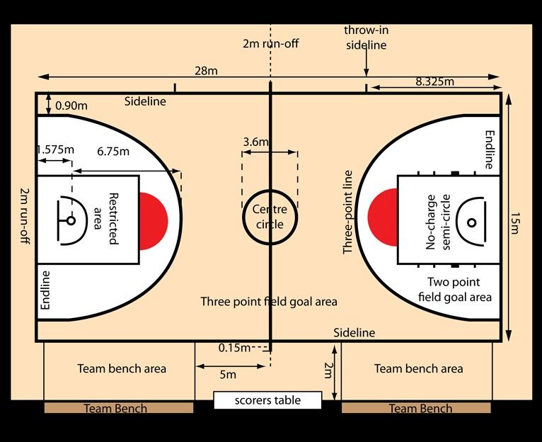 8 soccer fields, 18-hole frisbee golf course, access to Katy Tail, Clover Dell Lake, shelter, restrooms. The RC Track shown on the map is currently unusable.
Clover Dell park map here.
Clover Dell Park 3D Tour here
Directions:
From North: 65 Hwy to 32nd Street traffic light, turn right. There will be a fork in the road; you need to immediately turn right to stay on 32nd street. Continue on 32nd Street for approximately 1.5 miles, the park entrance is on the left.
From South: 65 Hwy to 32nd Street traffic light, turn left. There will be a fork in the road; you will need to turn right immediately to stay on 32nd Street. Continue on 32nd Street for approximately 1.5 miles, the park entrance is on the left.
East: 50 Hwy to 65 Hwy, turn left. 65 Hwy to 32nd Street traffic light, turn right. There will be a fork in the road; you need to immediately turn right to stay on 32nd street. Continue on 32nd Street for approximately 1. 5 miles, the park entrance is on the left.
From West: 50 Hwy to 65 Hwy, turn right. 65 Hwy to 32nd Street traffic light, turn right. There will be a fork in the road; you need to immediately turn right to stay on 32nd street. Continue on 32nd Street for approximately 1.5 miles, the park entrance is on the left.
Located in Clover Dell Park and free to the public. No membership or fee required! There is a fenced area for large and small dogs. Bring your friendly four-legged friends for some fun!
Dog Park Rules and Regulations
The third park included in the park system was Housel Park, which was acquired in 1942 and expanded in 1973 and 1984. Housel Park is located at Howard and Hurley and has an area of about five acres. Housel Park has one very active ball court, as well as restrooms, two cabins, a toddler playground, an illuminated basketball court, security lighting, swings, a slide, and ancillary facilities.
Map of Housel Park here.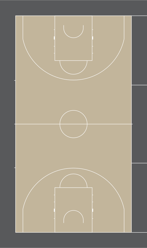
Housel Park 3D tour here
The second park in the Sedalia park system was Hubbard Park, which was donated by Mrs. Cotton in 1921. Hubbard is located on Johnson and Missouri Streets and has 23 acres. Hubbard consists of five cabins, lighting, fountains, two restrooms, a lighted baseball field, as well as swings, slides, a new modular play system, and two basketball courts. It also has a concession kiosk and ancillary facilities.
Map of Hubbard Park here.
Hubbard Park 3D tour here
Directions
From North: 65 Hwy to 3rd street, turn left. Third street to Missouri, turn left. The park will be on your left.
South: 65 Hwy to Main Street exit. After the exit, turn right onto Main St. Turn left onto Missouri Avenue, the park will be on your left.
From East: 50 Hwy to Grand Ave, turn right. Turn right onto Cooper Street. Turn left onto Missouri; the entrance to the park will be on your left.
From West: 50 Hwy to 65 Hwy, turn left. Main Street exit, turn right onto Main St. Turn left onto Missouri Avenue, the park will be on your left.
Opening May 26, 2022!
Final weekend - Friday, September 30 - Sunday, October 2.
Closing on Monday 3 October until next summer.
Opening Hours: 10 am - 8 pm
Free and open to the public
Terms of use of the site can be found here.
Unfortunately, there are no private rentals at this time.
The sixth park to be added to the system is Cathy Park. Katy Park is located on the corner of 24th and Grand and has an area of 18 acres. Recently, Katy Park has undergone some changes with a skate park, a modular playground, toilets, fountains and electricity in the cabins. Katy Park was purchased in 1974 and completed in 1976 with grant funds. It also has a baseball practice field, two recreational houses and one bouncer football driving range.
Map of Cathy Park here.
Katy Park 3D Tour here
Directions:
From North: 65 Hwy (Limit Avenue) to 16th Street, turn left. 16th Street to Grand Avenue, turn right. For the skate park, turn right onto Clinton Rd; the skate park will be on your left. For the playground and sheds, continue down Grand Avenue and turn right onto 24th Street; these zones will be on your right.
South: 65 Hwy (Limit Avenue) to 32nd Street, turn right. Turn left immediately onto Clinton Rd. For the playground and sheds, turn right onto 24th Street; the park areas will be on your left. For the skate park, continue on Clinton Road; the skate park will be on your right.
East: 50 Hwy to Grand Avenue, turn left. For the skate park, turn right onto Clinton Rd; the skate park will be on your left. For the playground and sheds, continue down Grand Avenue and turn right onto 24th Street; these zones will be on your right.
From West: 50 Hwy to Grand Avenue, turn right. For the skate park, turn right onto Clinton Rd; the skate park will be on your left. For the playground and sheds, continue down Grand Avenue and turn right onto 24th Street; these zones will be on your right.
KATY PARK (Clinton Road and Grand Avenue)
Completed September 2003
SKATE PARK RULES AND REGULATIONS
WARNING! The object is unattended and not insured.
Any use is at your own risk. Use may result in serious injury.
PROTECTIVE EQUIPMENT
We strongly recommend that you wear the following protective equipment at all times to ensure adequate protection in the event of a fall or collision:
Helmet * Knee pads * Elbow pads * Wrist pads
PLEASE REMEMBER
* The Skate Park is for skateboards, skateboards and inline skaters. Bicycles and scooters are prohibited.
Hours of permitted use are from 7:00 am to sunset. It is illegal for any person to enter the territory outside the established hours.
* The Sedalia Parks and Recreation Department is not responsible for any activities at this location.
* Do not use glass containers, food or drinks on the skating surface. Spilled products endanger riders.
* Other items such as benches, tables, wooden materials or other items used as ramps or springboards are not allowed in the skate park.
* Pets are not allowed on the skate park.
* It is forbidden to ride against the traffic.
* Do not leave the ramp until you have freed it from other skaters.
* Alcohol, tobacco and/or drugs are prohibited.
SEDALIA PARKS AND RECREATION DEPARTMENT
RESERVES THE RIGHT:
* Close the facility under any circumstances deemed necessary.
* Restrict entry to the property and deny access to the property if any of the
rules or if unsafe behavior is observed (Park Board Policy).
PLEASE REMEMBER
Ride safe and be aware that weather conditions can create unsafe surfaces to ride.
FACILITY MAINTENANCE
Please report maintenance issues to the park and recreation office 826-4930. Messages can be left 24 hours a day.
SERIOUS INJURIES
In the event of a serious injury or other emergency, call 911. The phone is located in the northeast corner of the parking lot, next to the walking trail. The facility is located in Katy Park, on the corner of South Grand and Clinton Road.
PLEASE BE POLITE AND RIDE FRIENDLY
Approximately 32 acres of Liberty Park was purchased in 1890 from Joseph Seacher. Today, Liberty Park is home to the main building, Convention Hall, which houses the parks and recreation office. The building has an auditorium for recreation programs, an upper floor for dance programs and conference rooms, as well as toilets.
The Parks Management and Operations Office is also located in Liberty Park. This office houses the maintenance staff and all the equipment to keep the facilities in proper condition.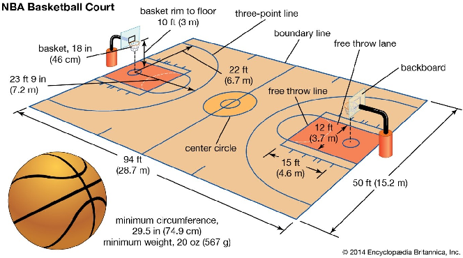
We have security lighting, fountains, playground equipment, two basketball courts, six floodlit tennis courts, six recreation houses, a recreational fishing lake, a rose garden, a floodlit baseball stadium with seating, restrooms and a concession kiosk, picnic areas, sand volleyball courts, the Liberty Land train with 1/8 mile track, and a lighted Little League baseball stadium.
Map of Liberty Park here.
Freedom Park 3D Tour here
Directions
From North: 65 Hwy (Limit Ave) to 3rd Street, turn left.
South: 65 Hwy (Limit Ave) to 3rd Street, turn right.
East: 50 Hwy to 65 Hwy, turn right. Turn right onto 3rd Street.
From West: 50 Hwy - 65 Hwy, turn left. Turn right onto 3rd Street.
Once you are on 3rd Street, Liberty Pool and other areas of Liberty Park will be on your left.
More information about the opening date of the 2022 season will be available soon.
Moore Railroad Home - Home of the Liberty Land Train
Hours of Operation
Saturdays 11:30am - 3:30pm
Sundays 1:00pm - 4:00pm
$2 per wristband for the whole day; cash only per day
All ages must purchase a bracelet
Snacks and goods from the railway house are available in the store!
Vermont Park - upgraded in 2017
The fourth park to be added to the system was Vermont Park in 1951. Pfeiffer Woods-Vermont Park is located on the corner of Vermont and 14th Street and is approximately 7 acres in size. Vermont Park was renamed Pfeiffer Woods - Vermont Park in 1986. Pfeiffer Woods-Vermont Park includes: basketball court, multi-purpose court, play areas, 2 small driving ranges, lighting and toilet shed, and a NEW walking path (.294 miles. 3.5 laps = 1 mile).
Map of Vermont Park here.
Vermont Park 3D tour here
Reservations are available from April 1st to October 31st.